In today’s globalized and high-tech world—in which data flow via fiber optic cable and satellites, and people typically travel long distances by air—most goods continue to be transported by sea. Whether it is manufactured products, such as appliances and consumer electronics; construction material, such as concrete and steel I-beams; or resources, such as food and fuel, most physical items still rely on traditional shipping through sea lanes to reach their markets. The United Nations Conference on Trade and Development estimates that some 10 billion tons of cargo was moved in 2015, mostly by sea.
Similarly, the seas remain a major focus for international security. While lighter military forces can move by air, most military equipment, and almost all of the logistical support, still requires ships. The C-17 Globemaster cargo aircraft, mainstay of the U.S. Air Force’s strategic airlift fleet, can only lift a single M-1 Abrams tank at a time—an American armored battalion has more than 50 M-1s. By contrast, a single Large, Medium-Speed, Roll-on/Roll-off ship (LMSR) can carry an entire U.S. Army Task Force, including “58 tanks, 48 other tracked vehicles, plus more than 900 trucks and other wheeled vehicles,” as well as a range of supplies.REF The U.S. Navy’s new Expeditionary Fast Transport (formerly known as the Joint High Speed Vessel) can move 600 tons of equipment 1,200 miles at a time.REF
Given the globalization of the world economy, and attendant globalization of threats, even continental powers—states traditionally more reliant on land power than sea power—find themselves depending on the world’s oceans. Although the People’s Republic of China (PRC) has traditionally been a continental power, it is now a net importer of energy and food, most of which travels by sea. It also heavily relies on exports for its economic growth. Beijing therefore depends on access to the world’s oceans to keep its people fed, its cities lit, and its factories working.
What Is Maritime Domain Awareness?
In this light, maritime domain awareness (MDA), maintaining watch over the world’s oceans and waterways, is a vital matter of security with major economic as well as military implications. This is especially true for the members of the Quadrilateral Security Dialogue (or “Quad”)—Australia, India, Japan, and the United States—the four democratic nations of the Indo–Pacific. As maritime powers, they depend on the seas for their very survival; consequently, any threat to the safety and security of the world’s sea lanes poses a direct threat to their national security. Maritime domain awareness is the awareness of anything associated with the global maritime domain as it relates to security, safety, economics, or the environment.REF It includes both maritime intelligence and maritime situational awareness. Maritime intelligence is the integration of all available information in order to identify, locate, and track potential threats in the maritime arena. Maritime situational awareness is the persistent monitoring of the maritime domain.
MDA is important, first and foremost, for monitoring a nation’s waterways (rivers and coastal); this is integral to national sovereignty. In addition, a nation typically will want to maintain MDA of its territorial waters, a band that extends 12 nautical miles from a coastal baseline, which starts at the low water mark. (Territorial waters have historically been based on the area covered by shore defenses; in the 19th century, this area was approximately three nautical miles, or the range of typical shore batteries of the day.)
Countries also have financial and security reasons to maintain MDA of the region beyond their territorial waters, up to 200 nautical miles. This area is the exclusive economic zone (EEZ). While territorial waters have long existed legally, the concept of the EEZ is fairly new, as it was first created under the 1982 United Nations Convention on the Law of the Sea (UNCLOS). Under UNCLOS, a state may claim an EEZ where it has the exclusive right to resources found in those waters (such as fish), on the sea bed (such as minerals), or beneath the sea floor (such as oil or gas). Consequently, states need a robust MDA capability in order to prevent illegal or unauthorized exploitation of the resources within the EEZ, such as fishing by outsiders.
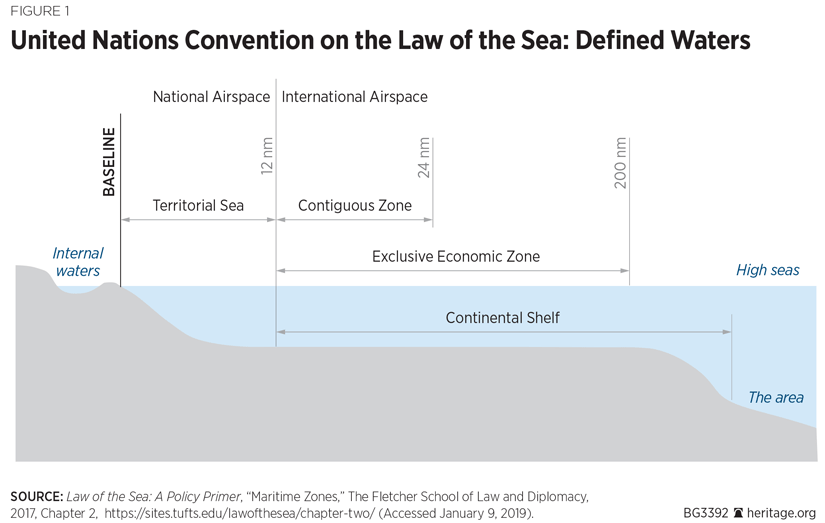
Finally, MDA is important on the “high seas,” the international waterways beyond the EEZ that are available for the use of all states. In particular, given the role of the global sea lanes of communications (SLOCs) in supporting the globalized supply chain, both governments and private entities, such as corporations, want to know the status of their shipments. While they may not think explicitly in terms of MDA, they do, in fact, have a strong interest in maintaining an awareness of maritime developments.
To this end, MDA encompasses a variety of elements. Given the impact of major weather events, such as hurricanes and typhoons, MDA must include a meteorological component. Knowing when a typhoon will pass through ocean waters, or over a harbor, is essential for allowing ships to either re-route from the storm, or to seek shelter in nearby harbors.
In addition, MDA is essential for countering criminal activities that occur within or through the maritime domain. This includes illegal fishing and other violations of national EEZs, piracy, drug trafficking, and human trafficking. All of these are issues in the maritime component of the Indo–Pacific, from the coastal waters off the Gulf of Aden to the SLOCs that transit the Straits of Malacca, to the South China Sea and the vast waters of the Central Pacific.
As seen in the South China Sea, a state’s MDA increasingly also involves detecting efforts by other states to alter the literal terrain and topography. China has built some 70 acres of new land in the Spratlys and Paracels, creating several new “islands” out of reefs and rocks.REF These islands incorporate underground facilities, runways on three islands, and various administrative buildings.REF Having created these artificial islands, China now demands that they be accorded the benefits typically associated with natural islands—including a 200-nautical-mile EEZ and associated territorial air space. While Chinese efforts are easily the most extensive in the South China Sea, other claimants in the region have also expanded their islets and reefs, including Malaysia and Vietnam.
Finally, improved MDA can support other policies. For example, sanctions against North Korea have been circumvented by Chinese and Russian provision of at-sea transfers of oil to North Korean vessels. As of September 2018, some 148 transfers had provided North Korea with perhaps a million barrels of illicit petrol, oil, and lubricants (POL).REF Many of these transfers occur on the high seas, outside any nation’s EEZ, and are therefore much harder to detect and monitor.
For a country to have a fairly complete MDA, it must collect the maximum amount of information about any ship or vessel within national waters, as well as its own EEZ. A country must also be aware of threats that might arise from international waters. Despite the investment of substantial resources by some countries, including the various members of the Quad as well as South Korea, Singapore, and the PRC, most countries’ ability to maintain MDA remains, at best, incomplete.
This fact was highlighted in the search for the lost Malaysian passenger flight MH370. Despite air traffic control’s radar tracking the aircraft’s initial flights and subsequent satellite updates (from the aircraft’s systems), it disappeared from regional air traffic and air defense radars. A subsequent three-year search, involving 26 nations, 60 ships, and 50 aircraft, has not resolved the fate of the hapless airliner.REF There is neither a single maritime monitoring authority, nor complete, 24/7, all-weather coverage of the world’s waterways and open ocean. Even where regions are under observation, states may not share that data for reasons of national security.
This is even more problematic due to the general decline in the number of available naval and maritime law enforcement platforms. The U.S. Navy, for example, is currently operating with fewer than 300 ships, set against a 355-ship requirement for global operations. The U.S. Coast Guard has 243 vessels that are more than 65 feet in length, but most of these are service vessels, such as buoy tenders and smaller patrol craft. The total number of National Security Cutters, High Endurance Cutters, and Medium Endurance Cutters available to patrol American EEZs (which include not only the East and West Coasts, but the waters around Alaska, Hawaii, Guam, and Puerto Rico) is only 37.REF
The challenge associated with MDA is only partly one of data collection. Thanks to the proliferation of ship-tracking technologies and surveillance systems and methods, there is a growing amount of available maritime information. But that information can only be useful once it is analyzed. Consequently, improved MDA requires not only more and better coverage of the world’s oceans (and associated activity above and below the surface), but also more analytical capacity.
Current MDA Efforts Around the World
Many states that rely on the sea are already undertaking steps to assure better MDA, typically through their maritime law enforcement agencies, which are usually a type of coast guard. These organizations are responsible for enforcing a state’s EEZ, intercepting illegal fishing, and countering smuggling and piracy. For less-wealthy states, MDA monitoring and other maritime law enforcement duties may also be a responsibility for their naval forces, either acting in support of a coast guard, or in lieu of one.
To some extent, MDA is embodied within the broader law enforcement and national security of coastal states. Maritime monitoring by coastal radars, harbor patrols, and general surveillance of the air and sea space around a nation contributes to MDA.
Such efforts are facilitated by a number of dedicated monitoring systems that are currently in place. The best-known is the Automatic Identification System (AIS). The AIS is required by the International Maritime Organization (IMO), the U.N. agency charged with regulating global shipping behavior. It is a very-high-frequency (VHF) transceiver system originally designed to help avoid collisions. Ships can read each other’s signals to about 20 nautical miles, while shore-based systems situated on high ground can read signals as far as 60 nautical miles away. AIS signals not only provide a ship’s course and speed but also its name, call sign, registration number, and classification.
The IMO requires AIS for all ships of 300 metric tons or more that conduct international voyages, cargo ships of 500 metric tons or more that operate solely in local waters, and all passenger ships irrespective of size. It is also installed aboard some military vessels, such as those of the U.S. Navy, although warships and naval auxiliaries are exempted from the requirement. Notably, of the approximately 17 million registered vessels worldwide, only some 200,000 are required to carry AIS. Moreover, some operators will turn off their AIS. Not surprisingly, these are mainly people engaged in illicit activities, such as smugglers and illegal fishermen.
Another identifier technology is the Long Range Identification and Tracking (LRIT) system. This is a satellite-based system installed aboard ships that are members of the IMO. LRIT employs additional data, and a separate data exchange network, which provides on-demand position information to queries, allowing real-time updates. LRIT is used by the U.S. Coast Guard to track vessels weighing more than 300 gross metric tons bound for American ports or traveling within 1,000 nautical miles of American shores.
Supporting Coast Guard and naval patrols are also various maritime surveillance systems, which typically involve sonar systems. These can identify not only submarines but surface ships. Sonar systems include fixed arrays deployed along the seabed, as well as towed arrays that may be operated from naval combatants or support ships.
Many states also deploy maritime patrol aircraft (MPA), such as the U.S.-made P-3 Orion and P-8 Poseidon, the Russian Il-38 May, the French Atlantique (and updated Atlantique 2), and the Chinese Y-8. MPA were originally designed to engage in open-ocean anti-submarine warfare. Consequently, they can engage in long-endurance missions, often numbering over 10 hours, and have a suite of sensors, including radar, magnetic anomaly detectors, sonobuoy systems, and sensitive antennae for detecting radio transmissions. Over the years, MPA have also been used to engage in electronic reconnaissance, as well as EEZ patrols, for which their extended flight times are well suited.
These methods are being supplemented by new developments in space and unmanned systems.
Space-Based Maritime Surveillance. During the Cold War, both the U.S. and Soviet Union deployed a number of satellites to monitor naval forces. These included electro-optical imaging satellites (which operated in the visible and infrared spectra) and radar-imaging satellites, such as synthetic aperture radar (SAR) systems. SAR systems use the flight path of the radar emitter (typically aboard a high-flying aircraft or satellite) to produce high-resolution images of objects or terrain features.REF SAR systems can operate through clouds, fog, and mist.
Since the end of the Cold War, more and more nations have been fielding satellites, including imaging systems. Equally important, in the past several years, private companies have also become major sources of space-based information. Consequently, even states that do not have their own space programs or satellite constellations can obtain space-based data.
One group of companies is fielding satellites designed to monitor AIS traffic. As AIS signals can be detected at much longer ranges from overhead systems, including low-earth orbit (LEO) satellites, satellite constellations can provide a much more comprehensive picture of regional maritime traffic patterns. This allows ship tracking on the high seas, not just mainly near shores or ports.
There are several companies that are currently fielding satellite-AIS systems, including Spire, ORBCOMM, and exactEarth. Each company has fielded a constellation of LEO microsatellites (typically in the range between 100 kg and 500 kg) with proprietary software that can monitor AIS signals from space. Each company’s constellation comprises a large number of satellites. Spire operates over 100 satellites; exactEarth operates more than 50.REF The number of satellites determines how frequently their information is updated, and therefore, how precisely they can track a given AIS signal, or monitor a given maritime region. The various satellite-AIS companies claim that they can update ship positions on the high seas as frequently as every hour—or less.
In addition to their own satellites, several of the companies have also arranged “hosted payloads,” that is, mounting instrument packages aboard other companies’ satellites.REF This arrangement allows them to provide additional coverage at reduced cost (by leasing space on other satellites, rather than building their own, with attendant costs for launch and operation).
Electro-Optical (EO) Imaging Satellites. Another group of companies is operating EO imaging satellites. These provide pictures based on various spectra of light, including not only the visible range (EO) but also infrared (referred to as EO/IR systems). Depending on the resolution of the satellite’s cameras, EO/IR systems can simply detect large objects, or they can provide sufficient detail to characterize that information, even to the point of determining the type of vessel. (The latter are typically associated with military and intelligence systems.)
EO/IR systems are subject to the vagaries of time and weather, however. Because they operate in the visible and IR spectra, they are usually unable to penetrate cloud cover. Similarly, EO systems cannot necessarily detect objects at night (since the background is dark). IR systems, however, may be better able to discriminate between a warmer object if placed against a colder background (such as a ship operating at night or in winter).
Synthetic Aperture Radar (SAR) Satellites. A new area of commercial space operations is SAR satellites. Because they can operate in all weather, SAR satellites can provide full-time monitoring of various maritime areas, including at night or in bad weather. This makes them an excellent complement to AIS and other vessel-monitoring systems. The problem with SAR systems is that they are far more complex. Because they are actively emitting a radar signal, they require significantly more onboard power, as well as associated radar transceivers. In order to generate a useful picture, the resulting data must also be heavily processed, either aboard the spacecraft or at a ground station. All of this has generally meant that SAR satellites are much more expensive and less reliable than their EO counterparts.
Advances in computing technology, however, have allowed faster data processing and advances in artificial intelligence, as well as greater reliability in electronics. Finland, for example, has now deployed a SAR-equipped micro-satellite. The ICEYE X-1 is a 70 kg satellite that carries a SAR system; it is also Finland’s first commercial satellite.REF As the cost for given levels of SAR capability has dropped, many believe that a market is emerging to support purely commercial SAR operators.REF At a minimum, one can expect a wider array of SAR operators, with a concomitant growth in the availability of SAR-based information.
South Africa, for example, has signed an agreement with Maxar Technologies to access the Canadian RADARSAT-2. This SAR capability will provide all-weather monitoring of South Africa’s extensive EEZ.REF
This deal highlights the fact that neither MDA nor space access is solely the purview of space powers. It is worth noting that, given the sale of satellites by both national and commercial entities, states with greater resources can now purchase individual satellites and associated launch services. In particular, the growth in small-satellites, which are commensurately much less expensive, means that states can become space operators in short order simply by purchasing one or several satellites, often at very low cost. Indeed, the growing capability of commercial space operators means that any nation, with enough money, can now obtain space-based MDA, either by purchasing satellites, or simply purchasing the data from commercial space systems.
Unmanned Aerial Vehicles (UAVs). The steady expansion of UAVs has led to the development of high-altitude, long-endurance (HALE) and medium-altitude, long-endurance (MALE) systems. Several of each type are well-suited for maritime missions or are specifically designed for them. Two American systems are the MQ-4C Triton and the ScanEagle. The former is a naval version of the Global Hawk HALE strategic reconnaissance UAV. The Triton is equipped with both EO and IR sensors, as well as radar, allowing it to engage in surveillance of maritime areas across a range of sensors, making it harder to spoof. In addition, it is outfitted with AIS receivers, so that it can identify ships by their AIS signature but can also identify those ships that might have turned off their AIS system (pirates or smugglers, for instance). With a mission endurance of over 24 hours, the Triton can provide persistent surveillance of a given location (a strait or suspected pirate base) or engage in extended patrols over wide areas, such as a state’s EEZ.
The ScanEagle is a much smaller system (35 pounds versus 32,000 pounds), intended to provide tactical information rather than undertake strategic missions. Yet, the ScanEagle can also stay airborne for over 24 hours, allowing its E/O or IR systems to maintain watch over an area from a much lower altitude.
It is notable that China has been operating a growing array of domestically produced UAVs, and the biennial Zhuhai Air Show has regularly included new models. Chinese BZK-005 UAVs, comparable to the American Global Hawk and Triton systems, have been seen undertaking maritime surveillance flights over the East China Sea for the past several years.REF China has also been actively exporting UAVs to a number of Middle East states. Algeria, Iraq, Jordan, Egypt, and the United Arab Emirates are all operating Chinese drones, some of which have been conducting not only observation but also strike missions.REF
The European Maritime Safety Agency, meanwhile, has let the largest contract for civilian maritime drones, valued at some 67 million euros over five years. The program is intended to improve European monitoring and surveillance of maritime activity. “Under the contract, drones are used to assist with border control, search and rescue operations and monitoring of pollution, as well as the detection of illegal fishing and drug and people trafficking.”REF
Looking forward, improvements in MDA will entail combining traditional methods with both space-based systems and UAVs. Various computer algorithms can sift through huge volumes of data and correlate both EO/IR and SAR images with available AIS data to produce highly accurate snapshots of ship locations.REF The Norwegian company Kongsberg, for example, offers a vessel-detection service that monitors particular maritime areas. “Vessels are detected in satellite imagery and for each vessel, information about geographical location (latitude/longitude), estimate vessel length and heading are provided.”REF Even turning off AIS and other locator systems does not allow such vessels to completely evade detection (although it can make characterization more difficult).
Growing Asian MDA Efforts
Various efforts at improving Asian MDA are already underway. The United States, with its network of alliances and commitments throughout the region, has long engaged in maintaining maritime situational awareness, complete with support from various satellite, surface, subsurface, and aerial platforms. Much of this has been undertaken in conjunction with its treaty allies (Japan, South Korea, the Philippines, Thailand, Australia, and New Zealand), especially in monitoring the maritime situation in the immediate vicinity of each ally. Moreover, Japan has committed to helping preserve sea-lane security into the central Pacific since the 1980s. Other countries are engaging in individual MDA efforts, apart from the United States.
Australia and New Zealand have long provided EEZ patrols and other MDA-related efforts to Central Pacific states, such as Tuvalu and Nauru. The Australian Pacific Maritime Security Program (PMSP), for example, has helped to provide offshore patrol vessels to 12 Pacific Island nations, allowing them to improve their monitoring and enforcement of EEZs. Meanwhile, Royal Australian Air Force P-3s have provided aerial surveillance of the huge areas involved.
In September 2018, India and France indicated they were developing a joint program of maritime surveillance satellites. This is part of a larger set of Franco–Indian defense and technology efforts, undertaken in accordance with agreements signed in March 2018. These specifically include space-related technologies. The Indian Space Research Organization and France’s National Center for Space Studies are committed to exploiting AIS to “monitor and protect the assets in land and sea.”REF The constellation of between eight and 10 satellites marks India’s most extensive joint space program with any other nation.
Vietnam has been very interested in adding space-based systems to its MDA efforts. Vietnam’s first earth-observation satellite, built by EADS-Astrium, was placed in orbit in 2013. Vietnam’s Natural Resources, Environment, and Disaster monitoring satellite (VNREDSat-1) has a 2.5-meter resolution in panchromatic mode—sufficient to discern larger vessels. In 2017, Vietnamese officials signed a contract with Japanese NEC Space Technologies to build two radar satellites (JV-Lotus 1 and 2), which will provide additional MDA capability. Meanwhile, Vietnamese engineers at the Vietnam Space Center have been studying in Japan and have built a small satellite, MicroDragon, with Japanese technical support. It is expected to be orbited by early 2019.REF
Recommendations for the Quad
All four members of the Quad are maritime powers. That is, they each heavily depend on free and open access to the world’s oceans for both their economic and military security. It is therefore in their interests that they be able to maintain MDA of their own national maritime boundaries as well of as the international sea lanes.
To this end, the four members of the Quad should undertake several measures to improve MDA.
Expand MDA Cooperation. Each Quad nation fields substantial naval and maritime law enforcement capabilities and is very experienced in maintaining MDA. Building on this shared set of capabilities and experiences should be a priority. This is likely to be facilitated by already existing cooperative efforts and common equipment fielded by the respective national forces. Three of the four states, for example, operate the P-8 Poseidon MPA. While Japan has chosen to build the Kawasaki P-1, its many years of operating the American-built P-3 Orion (which was also in the Australian inventory), mean that there is a shared base of standard operating procedures and experiences.
As important, the recently signed Communications Compatibility and Security Agreement (COMCASA) between the United States and India means that each member of the Quad can share data with any other member through the Link-16 military tactical data link network. As modern operations rely heavily on shared situational awareness, COMCASA will substantially improve the interoperability of the various forces.
This data sharing will require that the Quad nations’ navies and maritime law enforcement agencies interact more regularly in order to familiarize themselves with each other’s operating patterns as well as the local environmental conditions. Consideration should be given to forward deploying, or at least regularly rotating, ships from the respective coast guards to each other’s ports, in addition to naval visits. It may even be worth considering the creation, in the long term, of a Quad naval or coast guard on-call force, drawing upon ships that are deployed into each other’s regions.
Create an Indo–Pacific Regional Maritime Monitoring Structure. While the Quad members are dependent on the seas, they are not the only ones, especially in the Indo–Pacific region. Many other states in the Indo–Pacific also depend heavily on the oceans for their economic health and national security. While some states, such as Singapore, Taiwan, and South Korea, also have substantial MDA capacities, others, including the states of Oceania and the central Pacific, are far less capable of undertaking regular, never mind persistent, monitoring of their vast maritime boundaries. Insofar as various nations can all contribute to the overall maritime situational picture, this would help to promote MDA among all nations.
Such a monitoring structure, however, would require an organizational structure to coordinate information sharing. An Indo–Pacific regional maritime monitoring authority should include:
- A central information clearing house, employing AIS, LRIT, but also data derived from space-based maritime surveillance systems. Such a clearing house might be located in a central location, such as Singapore, Malaysia, or the Philippines. Alternatively, it might entail the creation of regional centers (one for the Indian Ocean, one for the Pacific, for instance). Various Asian states could forward information to the clearing house and receive regular updates on ship and air traffic in the region. States that are interested should be especially encouraged to provide space-based information, which could be of use not only for MDA, but also for disaster relief and environmental monitoring. The experience with MH370 clearly demonstrated the gaps that currently exist, even in something as central as air traffic control information. The clearing house could help ameliorate these gaps and problems.
- A regional training center for developing a cadre of intelligence analysts. For many of the states in the Indo–Pacific region, intelligence analysis, especially of space-derived information, is a new field. This is especially true for EO and SAR imagery. Analysis of AIS and other data, too, is something that may not be commonly undertaken in some of the less-well-off states. The Quad members should fund a training program to expand the pool of such analysts and also ensure that states such as Malaysia, Cambodia, and the Central Pacific island nations better understand what can (and cannot) be achieved through an expanded MDA program.
- Regional MDA training to familiarize the various states with each other’s concerns, operations, and training, tactics, and procedures. Whereas MDA-oriented training among the Quad should include military as well as law enforcement operations, regional MDA training should probably focus more on law enforcement activities. A law enforcement focus would be politically far less sensitive, while also addressing many of the real concerns of the region—piracy, human trafficking, illegal fishing operations, and smuggling. This would increase the burden on entities, such as the U.S. Coast Guard and the Japan Coast Guard, and argues for both additional forward deployment of ships and personnel, as well as increases in resourcing.
—Dean Cheng is Senior Research Fellow in the Asian Studies Center, of the Kathryn and Shelby Cullom Davis Institute for National Security and Foreign Policy, at The Heritage Foundation. Emma Childs, a member of The Heritage Foundation’s Young Leaders Program, made valuable contributions to this report.