
Abstract: Proponents of U.S. accession to the United Nations Convention on the Law of the Sea (UNCLOS) insist that the U.S. must join the convention in order to secure title to oil and gas resources located on the U.S. extended continental shelf (ECS). However, that argument has no basis in fact or law. Under international law and long-standing U.S. policy and practice, the U.S. has already established jurisdiction and control over its ECS and is in the process of delimiting the boundaries of its ECS. The United States as a sovereign nation can accomplish its objectives regarding the ECS and its resources without acceding to a deeply flawed treaty or seeking the approval of an international commission of experts housed at the United Nations.
Proponents of U.S. accession to the United Nations Convention on the Law of the Sea (UNCLOS) claim that unless the United States joins the convention, it will be unable to gain “international recognition” of the outer limits of the U.S. continental shelf beyond 200 nautical miles (nm), an area known as the “extended continental shelf” (ECS). For example, Senator Richard Lugar (R–IN), a long-time supporter of U.S. membership in the convention, maintains that accession is essential to establishing a valid claim to the U.S. ECS in the Arctic: “If the United States does not ratify this treaty, our ability to claim the vast extended Continental Shelf off Alaska will be seriously impeded.”[1]
Other supporters of the convention argue that international recognition of the U.S. ECS is absolutely conditional upon U.S. accession: “Countries must ratify the treaty for their claims to be internationally recognized.”[2] They argue that without such recognition, the United States will be unable to develop hydrocarbon resources that lie beneath the ECS, including in such resource-rich areas as the Gulf of Mexico and the Arctic Ocean.
However, these arguments lack basis in fact or law. The United States regularly demarcates the limits of its continental shelf and declares the extent of its maritime boundaries with presidential proclamations, acts of Congress, and bilateral treaties with neighboring countries. As a result of bilateral treaties between the United States and Mexico, the Department of the Interior’s Bureau of Ocean Energy Management currently leases areas of the U.S. ECS in the Gulf of Mexico to American and foreign oil and gas companies for exploration and development.
The United States may maintain jurisdiction and control over its ECS on a global basis, regardless of whether it ever accedes to UNCLOS, and it should take every action necessary to secure oil and gas resources located on its ECS in the Arctic Ocean, in the Gulf of Mexico, and throughout the world. The United States can accomplish this end while acting as a sovereign nation rather than by joining UNCLOS and seeking the approval of the Commission on the Limits of the Continental Shelf (CLCS), an international committee of geologists and hydrographers located at U.N. headquarters in New York City.
The U.S. Extended Continental Shelf
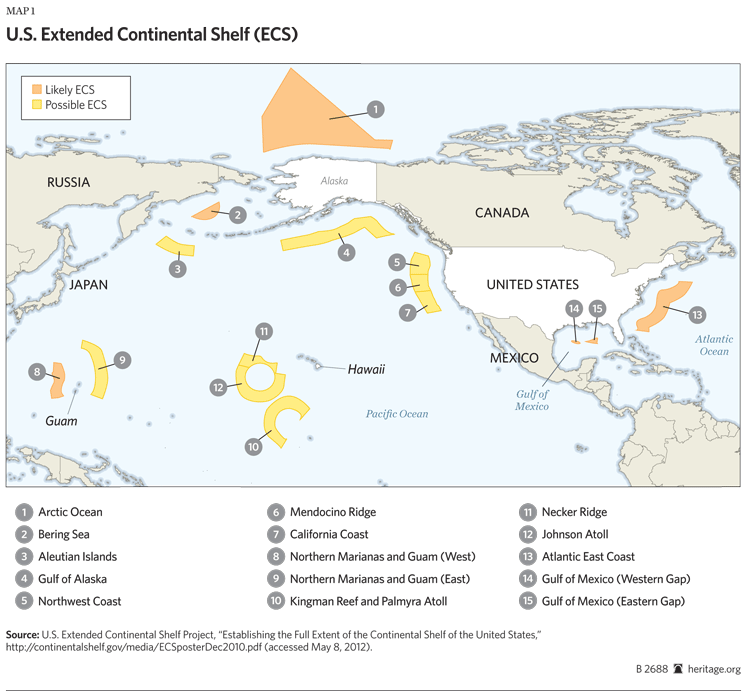
Since 2003, in an effort to define the outer limit of the U.S. continental shelf, the United States has collected bathymetric and seismic mapping data on the outer margins of its continental shelf in the Arctic Ocean, Gulf of Alaska, Gulf of Mexico, and Bering Sea; along the Atlantic and Pacific Coasts; and off the Northern Mariana Islands, Kingman Reef, Palmyra Atoll, Guam, and Hawaii. The U.S. Extended Continental Shelf Task Force, an interagency project, is conducting this data collection.[3] To date, the ECS Task Force has identified six areas that “likely” contain submerged continental shelf and qualify as ECS and nine areas that “possibly” qualify.
The value of the hydrocarbon deposits lying beneath the U.S. ECS is difficult to estimate, but it is likely substantial. According to the ECS Task Force, “Given the size of the U.S. continental shelf, the resources we might find there may be worth many billions if not trillions of dollars.”[4]
“International Recognition” of the U.S. ECS
Historical experience has repeatedly debunked the notion that achieving “international recognition” of U.S. maritime boundary and continental shelf claims requires UNCLOS membership. The United States has had no difficulty whatsoever in achieving recognition of such claims in the past. Since 1945, U.S. Presidents have issued proclamations and Congress has enacted laws on U.S. maritime claims and boundaries. None of these has been challenged by any nation, any group of nations, or the “international community” as a whole.
-
1945: Truman claims jurisdiction and control over the U.S. continental shelf and its resources and establishes a conservation zone for coastal fisheries. On September 28, 1945, President Harry S. Truman issued two proclamations, including the “Policy of the United States With Respect to the Natural Resources of the Subsoil and Sea Bed of the Continental Shelf,” which states in part:
Having concern for the urgency of conserving and prudently utilizing its natural resources, the Government of the United States regards the natural resources of the subsoil and sea bed of the continental shelf beneath the high seas but contiguous to the coasts of the United States as appertaining to the United States, subject to its jurisdiction and control.[5]
Truman’s second proclamation established a conservation zone for U.S. fishery resources contiguous to the U.S. coast.[6]
- 1953: Congress defines the U.S. continental shelf and reaffirms jurisdiction and control over its resources. Congress refined Truman’s continental shelf proclamation in 1953 when it enacted the Outer Continental Shelf Lands Act, which declared “the policy of the United States that…the subsoil and seabed of the outer Continental Shelf appertain to the United States and are subject to its jurisdiction, control, and power of disposition” and defined the outer continental shelf as “all submerged lands lying seaward and outside of the area of lands beneath navigable waters.”[7]
- 1983: Reagan declares a 200 nm exclusive economic zone (EEZ). After deciding in July 1982 not to sign UNCLOS, President Ronald Reagan announced his official oceans policy in March 1983. The announcement proclaimed “an Exclusive Economic Zone in which the United States will exercise sovereign rights in living and nonliving resources within 200 nautical miles of its coast.”[8] The pronouncement of the 200 nm EEZ was part of Reagan’s broader policy commitment to “accept and act in accordance with the balance of interests relating to traditional uses of the oceans,” which are reflected in the convention. The 200 nm EEZ conforms to the limit set forth in Article 57 of UNCLOS.
- 1988: Reagan declares a 12 nm territorial sea. In December 1988, Reagan followed up his 1983 EEZ proclamation by extending the breadth of the U.S. territorial sea from 3 nm to 12 nm in conformity with Article 3 of UNCLOS.[9]
- 1999: Clinton declares a 24 nm contiguous zone. Building on Reagan’s maritime proclamations, in September 1999, President Bill Clinton proclaimed an extension of the U.S. contiguous zone from 9 nm to 24 nm in conformity with Article 33(2) of UNCLOS.[10]
Proponents of UNCLOS offer no evidence that any foreign nation has not recognized or will not recognize the unilateral proclamations made by the United States. Yet the same proponents contend that the United States cannot hope to gain recognition of its ECS or assert jurisdiction and control over it unless and until it joins the convention. Law of the sea experts such as Ted McDorman at the University of Victoria disagree with that position:
It can be asked whether a non-party to the LOS Convention can legally exercise jurisdiction over its adjacent continental margin beyond 200 nautical miles or whether this entitlement is only available to parties to the LOS Convention. The answer is that there appears to exist sufficient state practice…to support the view that, as a matter of customary international law, states can legally exercise jurisdiction over the continental margin beyond 200 nautical miles irrespective of the State’s status as a LOS Convention ratifier.[11]
No evidence suggests that membership in UNCLOS is necessary, much less essential, either to gain international recognition of the U.S.’s ECS boundaries or to claim, legally and legitimately, jurisdiction and control over its ECS resources. It is telling that proponents of U.S. accession to UNCLOS do not claim that international recognition of the U.S. territorial sea, contiguous zone, or EEZ is contingent upon U.S. accession to the convention, yet they assert that accession is the sine qua non for international recognition of the U.S. ECS.[12]
Both international law and long-standing U.S. policy and practice establish that the United States is within its rights to demarcate the various areas of its ECS and expect other nations to recognize those boundaries. Although it is unnecessary to do so, once the United States completes the mapping and delineation of its ECS, it should confirm its jurisdiction and control over those areas by presidential proclamation in the manner of the Truman proclamation on the continental shelf, the Reagan proclamations on the EEZ and the territorial sea, and the Clinton proclamation on the contiguous zone.
There is no magic ritual for achieving international recognition of maritime and continental shelf boundaries. Foreign nations recognize and respect U.S. maritime claims and boundaries, and vice versa, as long as those claims and boundaries conform to widely accepted international law, including the various provisions of customary international law that are reflected in UNCLOS.
Like its other maritime claims, the United States will demarcate the limits of its ECS in a manner that conforms to international law. In November 1987, a U.S. government interagency group issued a policy statement declaring its intent to delimit the U.S. ECS in conformity with Article 76 of UNCLOS, which provides a formula for measuring the extent of a coastal state’s ECS. The pertinent part of the policy statement reads:
[T]he Interagency Group on Ocean Policy and Law of the Sea has determined that the proper definition and means of delimitation in international law are reflected in Article 76 of [UNCLOS]. The United States has exercised and shall continue to exercise jurisdiction over its continental shelf in accordance with and to the full extent permitted by international law as reflected in Article 76, paragraphs (1), (2) and (3). At such time in the future that it is determined desirable to delimit the outer limit of the continental shelf of the United States beyond two hundred nautical miles…such delimitation shall be carried out in accordance with paragraphs (4), (5), (6) and (7).[13]
The 1987 policy statement sets out a process for obtaining domestic approval and providing international notification of the delimited U.S. ECS:
After delimitation [of the ECS] is completed, the results of any such delimitation shall be…transmitted to the President for review. If approved, the Department of State shall transmit charts depicting the delimitation and other relevant information to the Secretary-General of the United Nations and any other organizations as the Interagency Group shall determine to be desirable.[14]
To provide international notice of its ECS boundaries, the United States should also deposit charts and geographical coordinates describing the outer limits of its ECS with the U.N. Secretary-General for inclusion in the Law of the Sea Bulletin.[15]
Despite the claims of UNCLOS proponents, the United States can successfully pursue its national interests regarding its ECS—particularly oil and gas exploitation—without first gaining universal international recognition of its outer limits. While such recognition may be a worthy achievement, it is of no consequence to U.S. national interests whether the 195 nations of the world affirmatively recognize America’s jurisdiction over its ECS in the Gulf of Mexico, the Arctic Ocean, and elsewhere.
While achieving unanimous international recognition for the borders of the U.S. ECS is unnecessary, it is important for the U.S. to negotiate on a bilateral basis with nations with which it shares maritime borders to delimit and mutually recognize each other’s maritime and ECS boundaries. This process is already underway in regions where the United States has presumptive areas of ECS, including resource-rich areas in the Gulf of Mexico and the Arctic Ocean.
U.S.ECS in the Gulf of Mexico
International cooperation on the delimitation of maritime boundaries is necessary in resource-rich areas such as the Gulf of Mexico. Proponents of U.S. accession to UNCLOS assert that unless the United States joins the convention, it will be unable to definitively delimit the boundaries of its ECS, gain international recognition for those boundaries, or develop the hydrocarbon resources of its ECS. However, the U.S. experience in the Gulf refutes each of those assertions.
Since the 1970s, the United States and Mexico have negotiated a series of bilateral treaties to delimit their maritime and continental shelf boundaries, including areas abutting ECS:
- In November 1970, the U.S. and Mexico signed a treaty to maintain the Rio Grande and Colorado River as the agreed international boundary between the two nations. As part of the treaty, the two nations demarcated their maritime boundaries in the Gulf of Mexico and the Pacific Ocean out to 12 nm.[16] The treaty entered into force on April 18, 1972.
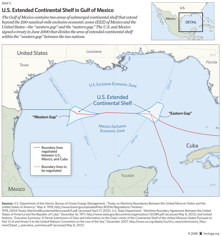
- In May 1978, building on the 1970 treaty, the two nations signed a treaty delimiting their maritime boundaries in the Gulf and in the Pacific out to 200 nm.[17] The treaty demarcated boundary lines in the Gulf where their respective 200 nm EEZs abutted, leaving a “doughnut hole” of approximately 5,092 square nm (now known as the “western gap”) where their 200 nm boundary lines did not meet. A second doughnut hole was created in the eastern Gulf where the EEZs of the U.S., Mexico, and Cuba fail to intersect (the “eastern gap”). The treaty entered into force on November 13, 1997.
- In June 2000, the U.S. and Mexico signed a treaty dividing the area of ECS within the western gap. Of the 5,092 square nm of ECS in the western gap, 1,913 (38 percent) went to the United States and 3,179 (62 percent) went to Mexico.[18] The treaty established a drilling moratorium over a narrow strip along the boundary within the western gap due to the possibility that transboundary hydrocarbon reservoirs are located along the boundary. The treaty entered into force on January 17, 2001.
- In February 2012, the U.S. and Mexico signed a treaty regarding the exploitation of transboundary reservoirs located along the continental shelf boundary shared by the two nations in the Gulf, including along the ECS boundary within the western gap.[19] The treaty has not yet been transmitted to the U.S. Senate for its advice and consent.
Collectively, these treaties between the United States and Mexico, particularly the June 2000 ECS delimitation treaty, demarcated an area of U.S. ECS—the 1,913 square nm of submerged continental shelf in the northern portion of the western gap. There is no evidence that any nation, any group of nations, or the international community as a whole does not or will not recognize the ECS in the northern portion of the western gap as subject to the jurisdiction and control of the United States.
Yet UNCLOS proponents commonly claim that U.S. companies will lack the “certainty” they require to develop the hydrocarbon resources located on the ECS unless the United States accedes to the convention and receives the approval of the Commission on the Limits of the Continental Shelf (CLCS). For example, in 2007, former Deputy Secretary of State John Negroponte stated, “In the absence of such international recognition and legal certainty, U.S. companies are unlikely to secure the necessary financing and insurance to exploit energy resources on the extended shelf.”[20] Another prominent advocate of U.S. accession has argued that U.S. failure to join the convention “could result in a loss of thousands of square kilometers of resource-rich…continental shelf.”[21]
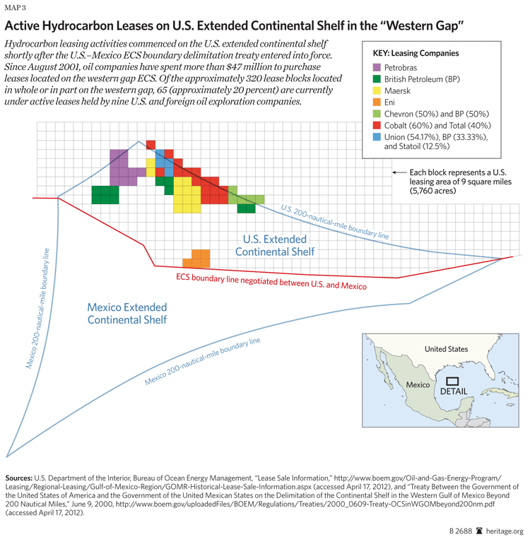
Reality tells a different story. The ECS area on the U.S. portion of the western gap has been available for development since August 2001. Specifically, the Bureau of Ocean Energy Management (BOEM)[22] offered the northern portion of the western gap for lease almost immediately after the 2000 U.S.–Mexico ECS delimitation treaty was ratified. That treaty entered into force on January 17, 2001. Seven months later, on August 22, BOEM offered the area of U.S. ECS in the western gap in Lease Sale 180. In that lease sale, three U.S. companies (Texaco, Hess, and Burlington Resources Offshore) and one foreign company (Brazil’s Petrobras) submitted successful bids totaling more than $2 million for seven lease blocks in the western gap.[23]
BOEM has offered the ECS blocks in the western gap in 19 lease sales between August 2001 (Lease Sale 180) and March 2010 (Lease Sale 213). In connection with those sales, seven U.S. companies (Burlington, Chevron, Devon Energy, Hess, Mariner Energy, NARCA Corporation, and Texaco) submitted bids to lease blocks in the western gap. Five foreign companies—British Petroleum, Eni Petroleum (Italy), Maersk Oil (Denmark), Petrobras, and Total (France)—also bid on western gap ECS blocks during those sales. BOEM collected more than $47 million in bids in connection with lease sales on those blocks.
Of the approximate 320 blocks located in whole or in part on the western gap ECS, 65 (approximately 20 percent) are currently held under active leases by nine U.S. and foreign oil exploration companies.[24]
The successful delimitation and subsequent leasing of areas in the Gulf of Mexico demonstrate that the United States does not need to achieve universal international recognition of its ECS. The United States identified and demarcated areas of ECS in the western gap in cooperation with the only other relevant nation, Mexico, and that area was subsequently offered for development to U.S. and foreign oil and gas companies.[25] All of this was achieved without U.S. accession to UNCLOS or CLCS approval.
Even though approximately 20 percent of the U.S. ECS that has been made available for lease by BOEM is currently under an active lease, the U.S. oil and gas industry has supported and will likely continue to support U.S. accession to UNCLOS in order to achieve even greater “certainty.”[26] That is their prerogative, of course, and achieving a maximum amount of certainty is a legitimate and desirable goal for a capital-intensive commercial enterprise. However, the successful delimitation of the ECS in the western gap would appear to have provided the certainty necessary for several major U.S. and foreign oil exploration companies to begin developing hydrocarbon resources on the Gulf ECS.
The U.S. experience in the Gulf should serve as a model for future bilateral negotiations and treaties with other nations that share ECS boundaries with the United States. For example, the U.S. should negotiate a treaty with Mexico and Cuba to delimit their respective areas of ECS in the eastern gap in the Gulf of Mexico.[27]
U.S. ECS in the Arctic Ocean
Another area of the ECS that is of particular importance to the United States is in the Arctic Ocean. There has been much hand-wringing among proponents of U.S. accession to UNCLOS over access to Arctic resources. In general, proponents contend that the U.S. ability to exploit ECS resources in the Arctic is contractual in nature vis-à-vis UNCLOS: In other words, the right to exploit the ECS in the Arctic depends on U.S. accession to UNCLOS. For example, in September 2007, Michael Chertoff, former Secretary of the Department of Homeland Security, characterized the necessity of U.S. accession as follows:
Moreover, our extended continental shelf has enormous potential oil and gas reserves, particularly in the Bering Sea and Arctic Ocean. Only by becoming a party to the Law of the Sea Convention and participating in its processes can the United States obtain secure title to these vast resources.[28]
John Bellinger, former Legal Adviser to the U.S. State Department, has also implied that failure to accede to the convention will impede the U.S.’s ability to exploit its Arctic ECS: “While [Russia, Canada, Norway, and Denmark] laugh all the way to the oil and gas bank, the U.S. sits on the sidelines unable to claim the resources on its extended continental shelf in the Arctic because it is not a party to the Law of the Sea treaty.”[29]
Much of the supposed distress voiced by UNCLOS proponents stems from Russia’s 2001 submission to the CLCS, in which Russia laid claim to a vast area of Arctic ECS. The proponents incorrectly imply that Russia’s claim will result in the loss of Arctic resources that rightfully belong to the United States. According to Senator Lisa Murkowski (R–AK), for example:
[I]f we do not become a party to the treaty, our opportunity to make [a claim to the CLCS] and have the international community respect it diminishes considerably, as does our ability to prevent claims like Russia’s from coming into fruition. Not only is this a negligent forfeiture of valuable oil, gas and mineral deposits, but also the ability to perform critical scientific research.[30]
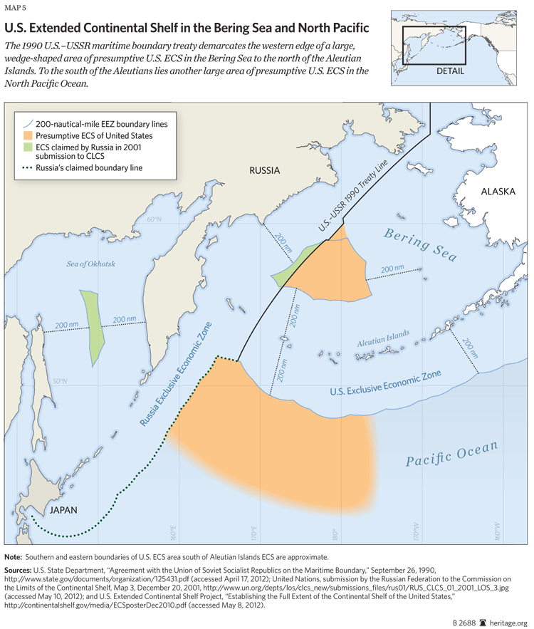
However, Russia’s 2001 submission to the CLCS in no way overlaps or infringes on potential areas of U.S. ECS in the Arctic. To the contrary, Russia’s claim adheres to a boundary line that the United States and the USSR agreed upon in a 1990 treaty.[31] Specifically, Russia’s submission to the CLCS divides its claimed continental shelf and ECS from the U.S. shelf along an agreed boundary line that extends from the Bering Strait northward into the Arctic Ocean.
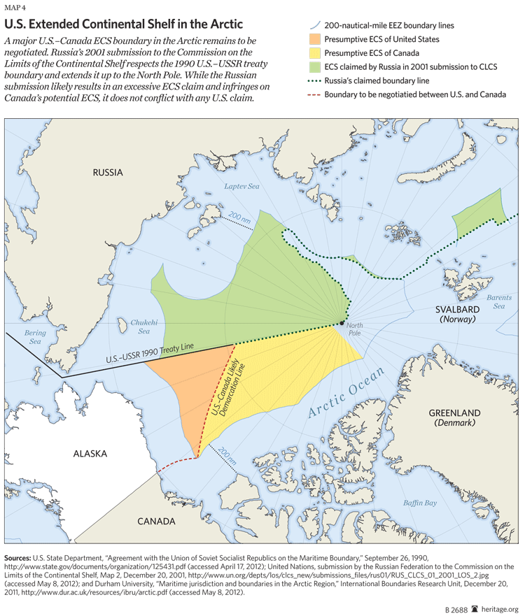
In a letter submitting the 1990 U.S.–USSR treaty to President George H. W. Bush, former Secretary of State James Baker specifically noted that the treaty demarcated an ECS boundary line with the USSR: “[The treaty] also delimits, as between the Parties, such continental shelf jurisdiction beyond 200 nautical miles from their coasts as they may exercise in accordance with international law in the Arctic Ocean, Bering and Chukchi Seas and a portion of the North Pacific Ocean.”[32] To the present day, the U.S. Department of the Interior has used the 1990 boundary line to demarcate the U.S.–Russia continental shelf boundary for the purpose of mapping and leasing areas for oil and gas exploration in the Chukchi and Bering Seas.[33]
That said, Russia’s 2001 CLCS submission extends the U.S.–USSR boundary line from the Bering Strait all the way to the North Pole, likely resulting in an excessive ECS claim in the central Arctic. However, Russia’s potentially excessive claim is located to the north of the presumptive U.S. ECS area, and while the claim may infringe on Canada’s potential ECS area, it does not conflict with any U.S. claim.[34] Even if it did, Russia’s claim would not be approved by the CLCS or recognized by the United States or Canada. UNCLOS provisions and CLCS procedural rules prevent the commission from approving an ECS boundary claim if there is a dispute: “In cases where a land or maritime dispute exists, the Commission shall not consider and qualify a submission made by any of the States concerned in the dispute.”[35]
Indeed, after Russia made its 2001 claim, five nations (Canada, Denmark, Japan, Norway, and the United States) submitted objections to the CLCS. The U.S. objection identified “major flaws” in the Russian claim, including an objection concerning whether the Alpha-Mendeleev and Lomonosov mid-ocean ridges in the central Arctic are a natural component of Russia’s continental shelf. However, the U.S. comments also noted that “the Russian submission utilizes the boundary embodied” in the 1990 U.S.–USSR treaty and that the “use of that boundary is consistent with the mutual interests of Russia and the United States in stability of expectations.”[36]
The CLCS agreed with the U.S. comments, stating that the U.S.–USSR boundary demarcated in 1990 reflects the boundary of the U.S.–Russia continental shelf in the Bering Sea. The CLCS recommended that Russia “transmit to the Commission the charts and coordinates of the delimitation lines as they would represent the outer limits of the continental shelf of the Russian Federation extended beyond 200 nautical miles in…the Bering Sea.”[37]
In June 2002, in light of the objections to Russia’s ECS claim, the CLCS recommended to the Russians that they provide a “revised submission” on Russia’s claims in the central Arctic.[38] Russia reportedly will make an amended submission to the CLCS at some point in the future. In addition, Canada and Russia recently signaled that they will cooperate with each other to demarcate their respective ECS boundaries in the Arctic.[39]
The U.S. objections to the Russian ECS submission and the CLCS’s subsequent rejection of the Russian claim call into question the repeated assertions by UNCLOS proponents that, absent U.S. accession to the convention, the United States is a helpless bystander in demarcation of Arctic ECS boundaries.[40] In fact, the United States has raised objections to the CLCS on other ECS submissions, such as those made by Australia and Brazil.[41]
In sum, the three areas of continental shelf boundary shared by the United States and Russia—in the Arctic Ocean, the Bering Sea, and the North Pacific—have been demarcated and mutually recognized by both nations, both in fact and in practice. Russia has not attempted at any time to infringe on potential areas of U.S. ECS in those regions. To the contrary, in its 2001 submission to the CLCS, Russia defined its continental shelf in a manner consistent with the 1990 treaty with the United States.
Similar to its experience with the western gap in the Gulf of Mexico, the United States has secured jurisdiction and control over areas of its ECS through bilateral negotiations with Russia. Specifically, the 1990 U.S.–USSR maritime boundary treaty demarcates a large, wedge-shaped area of presumptive U.S. ECS in the Bering Sea, north of the Aleutian Islands. The 1990 treaty also marks the western boundary of presumptive U.S. ECS in the Arctic Ocean.
However, an area in the North Pacific Ocean, where the U.S. may have a significant area of ECS, still requires demarcation. Russia’s 2001 submission to the CLCS identifies this boundary line, which extends from the southernmost point of the 1990 treaty line to the southwest as far as Hokkaido Island, Japan. The U.S. and Russia should negotiate a bilateral treaty to establish the coordinates of that line in conjunction with Russia’s forthcoming revised submission to the CLCS.
The major U.S. ECS boundary that remains to be determined in the Arctic is shared by the United States and Canada. As is the case with Russia, the U.S. and Canada have approached the demarcation of this boundary in cooperation with one another. The two nations have a mutual interest in determining the extent of their respective continental shelves and identifying their respective areas of ECS.
To that end, every year since 2008, the U.S. and Canada have conducted joint operations in the Arctic to collect bathymetric and seismic data to map the ECS. The data collected from those missions will supplement information collected in the Arctic by U.S. research vessels in 2003, 2004, and 2007.[42] These data will enable the United States and Canada to negotiate a bilateral treaty delimiting their respective continental shelves and areas of ECS in the Arctic in the same manner as the U.S. and Mexico did in the Gulf. The data will also likely help to settle a long-standing maritime boundary dispute in the Beaufort Sea.
The U.S. ECS Task Force is actively collecting data in other areas around the globe where the United States has presumptive areas of ECS. In addition to the Arctic Ocean and the Bering Sea, the task force has surveyed potential ECS areas off the U.S. Atlantic and Pacific Coasts, in the Gulf of Alaska, around the Kingman Reef and Palmyra Atoll, at the Necker Ridge near Hawaii, in the Northern Mariana Islands, and near Guam.[43]
Once the mapping is complete, the United States will be in a position to negotiate ECS boundary treaties with nations that have maritime or continental shelf boundaries appurtenant to U.S. territories, including Japan and Micronesia (in regard to potential ECS associated with the Northern Marianas); Kiribati (in regard to the Palmyra Atoll); and the Bahamas (in regard to the southern end of the U.S. Atlantic Coast). The United States and Canada will need to negotiate one or more treaties to delimit potential areas of ECS located in the Gulf of Alaska and areas associated with their Atlantic and Pacific maritime borders.
To summarize, despite dire warnings from the proponents of U.S. accession to UNCLOS, actual events demonstrate that the United States need not join the convention to delimit areas of its ECS, secure jurisdiction and control over those areas, and commence development of the hydrocarbon resources beneath the ECS. The United States is actively doing so in several crucial, resource-rich regions, including the Gulf of Mexico, the Arctic Ocean, and the Bering Sea. Such delimitation has been and will continue to be conducted in cooperation with neighboring countries, including Mexico, Russia, and Canada, regardless of whether the U.S. is a member of UNCLOS.
A Note on U.S. Rights to Deep Seabed Resources
Similar to the U.S. ECS, no legal barriers block U.S. access, exploration, and exploitation of the resources of the deep seabed—the ocean floor lying beyond the ECS and designated as “the Area” in UNCLOS. The United States has long held the position that U.S. corporations and citizens have the right to explore and exploit the resources of the deep seabed and may do so whether or not the United States is an UNCLOS member.
The United States made its position very clear in March 1983 during the final days of the Third U.N. Conference on the Law of the Sea. Specifically, in response to statements from other U.N. member states that non-parties would not have the right to engage in deep seabed mining, the U.S. stated the following:
Some speakers asserted that existing principles of international law, or the Convention, prohibit any State, including a non-party, from exploring for and exploiting the mineral resources of the deep sea-bed except in accordance with the Convention. The United States does not believe that such assertions have any merit. The deep sea-bed mining regime of the Convention adopted by the Conference is purely contractual in character. The United States and other non-parties do not incur the obligations provided for therein to which they object.
Article 137 of the Convention [forbidding claims of sovereignty over the deep seabed or its resources] may not as a matter of law prohibit sea-bed mining activities by non-parties to the Convention; nor may it relieve a party from the duty to respect the exercise of high seas freedoms, including the exploration for and exploitation of deep sea-bed minerals, by non-parties. Mining of the sea-bed is a lawful use of the high seas open to all States…. The practice of the United States and the other States principally interested in sea-bed mining makes it clear that sea-bed mining continues to be a lawful use of the high seas within the traditional meaning of the freedom of the high seas.[44]
The U.S. legal position set forth in 1983 on deep seabed mining remains the same today. According to the Restatement of the Law, Third, of the Foreign Relations Law of the United States, the United States may engage in deep seabed mining activities even if it does not accede to UNCLOS, provided that such activities are conducted without claiming sovereignty over any part of the deep seabed and as long as the mining activities are conducted with due regard to the rights of other nations to engage in mining.[45] As related by the Restatement, “like the fish of the high seas the minerals of the deep sea-bed are open to anyone to take.”[46]
The U.S. position is also reflected in the Deep Seabed Hard Mineral Resources Act of 1980, which Congress enacted two years before the adoption of UNCLOS to provide a framework for U.S. corporations to conduct deep seabed mining until such time as the United States joins an acceptable convention on the law of the sea.[47] The DSHMRA states the U.S. position on the legality of deep seabed mining as follows:
[I]t is the legal opinion of the United States that exploration for and commercial recovery of hard mineral resources of the deep seabed are freedoms of the high seas subject to a duty of reasonable regard to the interests of other states in their exercise of those and other freedoms recognized by general principles of international law.[48]
In sum, the long-held position of the United States, both domestically and internationally, is that U.S. citizens and corporations have the right to explore and exploit the deep seabed regardless of whether or not the United States is a party to UNCLOS.
What the U.S. Should Do
The United States has successfully secured its hydrocarbon resources in the western gap ECS area in the Gulf of Mexico and has leased that area to U.S. and foreign companies for development since 2001. The United States should build on the western gap model by negotiating a series of bilateral boundary delimitation treaties with nations with which it shares maritime and ECS boundaries and by taking whatever other steps are necessary to secure its ECS resources.
- Mexico and Cuba (the eastern gap). The United States should negotiate with Mexico and Cuba to delimit their ECS boundaries in the eastern gap in the Gulf of Mexico. Once the ECS areas in the eastern gap are divided among the three nations, the Bureau of Ocean Energy Management will be in a position to offer those areas for lease in the same manner that ECS areas in the western gap have been leased since 2001.
-
Russia (the North Pacific). No additional bilateral treaties with Russia are necessary to delimit the areas of potential U.S. ECS located in the Bering Sea and the Arctic Ocean. The 1990 U.S.–USSR treaty delimits the boundary from the Bering Strait north into the Arctic Circle. To the south, it establishes the western edge of a “wedge” of U.S. ECS located in the Bering Sea.
In the North Pacific Ocean, the U.S. and Russia should negotiate a bilateral treaty to establish the coordinates of the boundary line that extends from the southernmost point of the 1990 treaty line to the southwest as far as Hokkaido Island, Japan. Russia’s 2001 submission to the CLCS identifies this line, and the treaty could be negotiated in conjunction with Russia’s expected revised CLCS submission.
-
Canada (the Arctic and elsewhere). Significant maritime boundaries remain to be negotiated between the United States and Canada in the Arctic Ocean and elsewhere. The United States has a large, triangle-shaped area of presumptive ECS in the Arctic that borders Canada’s presumptive ECS.
The United States and Canada have cooperated closely to gather the data necessary to identify areas of ECS in the Arctic and should extend that cooperation to the negotiation of a mutually acceptable bilateral treaty delimiting their ECS boundary. Additional treaties between the U.S. and Canada will be required to delimit potential ECS areas in the Gulf of Alaska and in areas appurtenant to the Atlantic and Pacific maritime borders of the two nations. The U.S.–Canada treaties could be negotiated in conjunction with Canada’s expected submission to the CLCS, which is due by the end of 2013.[49]
- The Pacific islands. In addition to the Arctic and the Gulf, the United States has presumptive areas of ECS scattered throughout the Pacific Ocean appurtenant to U.S. territories, including Guam, Johnson Atoll, the Northern Mariana Islands, and Palmyra Atoll. The potential areas of U.S. ECS associated with these territories abut the maritime boundaries of several nations, including Japan, Kiribati, and Micronesia. Bilateral treaties with those nations would reaffirm U.S. jurisdiction and control over vast areas of ECS in the Pacific.
- Presidential ECS proclamation. Once the full extent of the U.S. ECS has been mapped and demarcated by the United States in cooperation with its neighbors, the President should issue a proclamation confirming U.S. jurisdiction over and control of the ECS and all of its resources, similar to the series of proclamations issued by Presidents Truman, Reagan, and Clinton on the continental shelf, the exclusive economic zone, the territorial sea, and the contiguous zone. While such a proclamation is legally unnecessary and redundant to the Truman Proclamation, the Outer Continental Shelf Lands Act, and other U.S. policy statements, it would clarify to the international community that the United States is asserting jurisdiction over its ECS in conformity with customary international law and Article 76 of UNCLOS.
Through these actions, the United States can continue to secure its hydrocarbon resources on a global basis, regardless of whether it ever accedes to UNCLOS.
The United States is unlikely to accede to UNCLOS in the near term, or perhaps ever. However, this does not mean that the United States should not take every action necessary to secure oil and gas resources on its extended continental shelf in the Arctic Ocean, the Gulf of Mexico, and throughout the world. The United States can accomplish this end while acting as a sovereign nation, continuing the tradition of American Presidents in proclaiming the nation’s maritime and resource rights, and without acceding to a deeply flawed treaty or seeking the approval of an international commission of experts housed at the United Nations.
—Steven Groves is Bernard and Barbara Lomas Fellow in the Margaret Thatcher Center for Freedom, a division of the Kathryn and Shelby Cullom Davis Institute for International Studies, at The Heritage Foundation and a contributor to ConUNdrum: The Limits of the United Nations and the Search for Alternatives (Rowman & Littlefield Publishers, 2009).